Advancing Environmental Insight with Esri
Esri conference updates and a closer look at our work with the Environmental Defense Fund
From custom applications and automated workflows to direct engagement with the Esri community, Stone's GIS team is focused on helping clients make better use of their data. This month, we're spotlighting our work with the Environmental Defense Fund (EDF) and sharing details about upcoming Esri events.
Project Spotlight: Helping Environmental Defense Fund Turn Complex Data Into Actionable Insights
We’re proud to spotlight our ongoing work with the Environmental Defense Fund (EDF) on the Proximity Mapping Application: Environmental Stressors Assessment Tool. This web-based tool empowers EDF staff to understand the characteristics of populations living near specific facilities or pollution sources by combining geospatial data with demographic and health-related census information. The application supports repeatable analyses that inform research, advocacy, and decision-making around environmental and public health impacts, making complex spatial and demographic analysis accessible to non-technical users. Our work with EDF has spanned multiple phases, beginning with re-engineering Python-based geoprocessing scripts to significantly reduce processing times. We then transitioned the application from ArcGIS Web AppBuilder to ArcGIS Online Experience Builder as platform capabilities evolved, and have continued to develop custom widgets for more flexible user interaction with analysis outputs.
This collaboration has helped us better define client needs, identify functionality gaps, and create valuable opportunities to engage directly with Esri developers and advocate for enhancements that benefit not only EDF, but the broader user community.
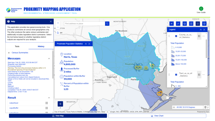
Screenshot from EDF’s Proximity Mapping Application showing the results of the Census Summaries tool analyzing data for populations in Texas living within 2 miles of U.S. and Canadian oil refineries.
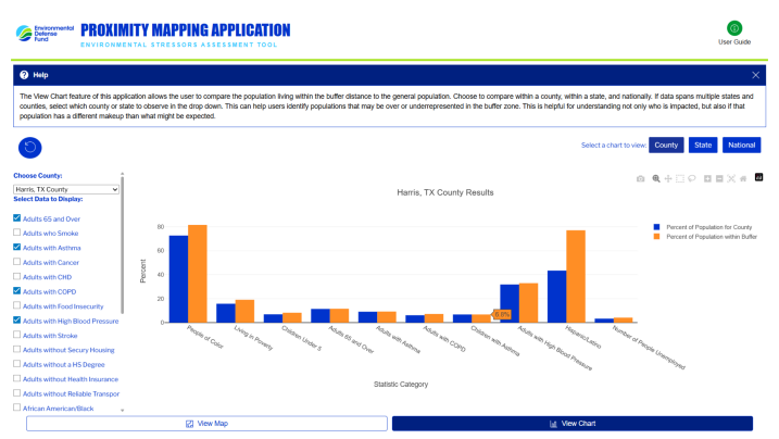
Custom charting widget developed to support detailed and flexible interaction with the EDF Proximity Tools analysis results.
Connecting with the Esri Community: Esri Partner Conference + Developers Summit
Stone's GIS team will also participate in two upcoming Esri events in Palm Springs, California, from March 8-13. Katie Budreski, Geospatial & Data Solutions Services Lead, will attend the Esri Partner Conference, while Mary Haley, Project GIS Specialist, will participate in the Esri Developer & Technology Summit. These events provide valuable opportunities to explore emerging capabilities across the Esri ecosystem, connect with platform developers, and bring client needs into conversations about the future of GIS technology.
Connect with us at these events—email Katie or Mary to set up a meeting.